Albany, New York Crime Trends
Article published April, 2025.
Has Albany's Crime increased or decreased?

An Independent Look at Albany Crime Data: Part 1
Note - This is the first of a multi-part article on Albany's Crime. Part 1 of this series of articles focuses on overall crime trends. Part 2 will focus on crime and location. Additional articles will drill into other aspects of Albany's crime data. In part 2 we wil include a link to the source data and any additional data elements that we added to the source data. This will allow anyone to download the data and analyze, replicate or challenge our findings.
In our analysis below we study Albany's crime data from 2020 through the end of 2024. Drawing specific conclusions from the crime data, especially given the uncertainty in the statistics, can be both challenging and subjective. In our analysis below we come to a number of directional statements:
- While it is positive to see a general decline in 2024 crime statistics, we are skeptical that Albany can make a broad claim that crime has materially gone down; our view of the data suggests that another 4 to 6 quarters would be required to validate any downward trend (or not).
- We see different trendlines when comparing violent crimes (not decreasing, potentially increasing) and theft crimes (decreasing) which could be a significant contributor to the perception of crime trends in our City.
- While out of scope for the analysis in Part 1, we would want to understand how Albany's crime trends mirror (or not) the nationwide crime trends over the study period.
- We have analyzed and provided our perspective on the crime statistics. We want to understand how the Albany Police Department looks at this data, and what the APD infers.
Analysis Overview
Instances of crime can impact our perception of a neighborhood or city as a whole. These conversations take place between neighbors, in anonymous online discussions and with prospective home buyers. One of our reasons for publishing this story was to highlight that not only is crime data collected and analyzed by the Albany Police Department, but that thoughtful and unbiased analysis of that data should be the cornerstone of our conversations.
We also feel strongly that important data like this should be readily available on Albany's Open Data site, and that this data should not require a FOIA. FOIAs are unnecessary barriers to viewing, analyzing, and reporting data collected by city employees in the form of public records. The Albany Police Department has been the biggest contributor to Albany's Open Data site, however comprehensive crime data was not available. It was necessary to use the Freedom of Information Act to request and obtain crime data from 2020 to the present (March 2025).
From our FOIA request we obtained over 78,000 recorded crime instances starting January 1st, 2020. As we examined the data, we had no preconceived notion of how the data would unfold. As we present our findings, we do our best to explain why we chose to group certain categories and why we selectively excluded certain data.
While performing the analysis on the crime data, the Times Union published an article (https://www.timesunion.com/news/article/albany-s-mayoral-candidates-tackle-public-safety-20213412.php) discussing Albany’s mayoral candidates' views on crime in the city of Albany. There are quotes from Dorcey Applyrs, Dan Cerutti, Corey Ellis, and Carolyn McLaughlin. Although every candidate spoke about their perspective on crime, no candidate directly referenced Albany's crime data to support their positions or policies. We hope our article brings data into the political discourse, and that candidates acknowledge trends occurring in Albany and that the policies they’re advocating for are rooted in facts.
We, the authors, recognize that collecting and analyzing crime data is challenging. In the 5-year study period, a) it’s possible that procedural changes may have occurred in how crime data is collected, b) the data was collected over a period that encompassed the 2020 and 2021 lockdown periods, c) police staffing levels were not consistent, and d) the data may or may not account for other agencies responding to crime incidents. We decided it is better to analyze the data on hand and note that these different factors may have an impact to our results rather than attempt to make erroneous corrections to the data.
Lastly, while we are looking at crime data with an analytical view we do not wish to ignore the mental and physical toll that crime has on victims, and our analysis is not a criticism or critique of the Albany Police Department.
Albany's Crime Data
The FOIA crime data that we received had 78,094 incidents with dates between Jan. 1st, 2020, and Mar. 8th, 2025. In each case, incidents were tagged with a date, location type (e.g., Amusement Center, Parking Lot), crime classification (which is not regularly filled in), uniform crime report, and hundred block (general location, i.e., 700 Block of Park Ave, Madison Av & Lark St). A snippet of that data is provided below in Table 1.
We define the entire list as "incidents" because under the heading UNIFORM CRIME REPORT, there are several incidents tagged as NO CRIME or ALL OTHER.
| Incident | Report Date | Report Day | Crime Classification | Locaiton Type | Uniform Crime Report | Hundred Block |
|---|---|---|---|---|---|---|
| 19178859 | 1/2/2020 | TUE | PERSON DOM VIOLENCE | MULTIPLE DWELLING | SIMPLE ASSAULT | 300 SECOND ST |
| 19184574 | 1/3/2020 | TUE | PARKING LOT | CRIMINAL MISCHIEF | 1000 MADISON AV | |
| 20000003 | 1/1/2020 | WED | AMUSEMENT CENTER | CRIMINAL MISCHIEF | 000 S PEARL ST | |
| 20000014 | 1/1/2020 | WED | NOT APPLICABLE | MULTIPLE DWELLING | NO CRIME | 500 SECOND ST |
Categorizing Albany's Crimes
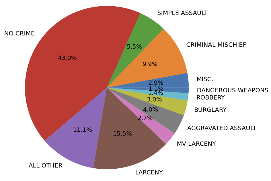
Figure 1, above, displays all recorded incidents grouped by UNIFORM CRIME REPORT between Jan. 1st, 2020, through Mar. 8th, 2025. The MISC. field contains the sum of all entries that constitute less than 1%, i.e., MURDER.
A significant portion of the incidents were classified as NO CRIME (43.0%) or ALL OTHER (11.1%). Under CRIME CLASSIFICATION, many of these were tagged with NOT APPLICABLE, NOT REPORTED, or PERSON DOM VIOLENCE. Due to the lack of sufficient clarity regarding the nature of these incidents, dividing them into subcategories becomes more challenging; therefore, all incidents tagged with either NO CRIME or ALL OTHER were removed from many of the analyses presented here. With the removal of these data, the remaining data is referred to as crimes or crime data. Rebalancing the ratios is presented below in Figure 2.
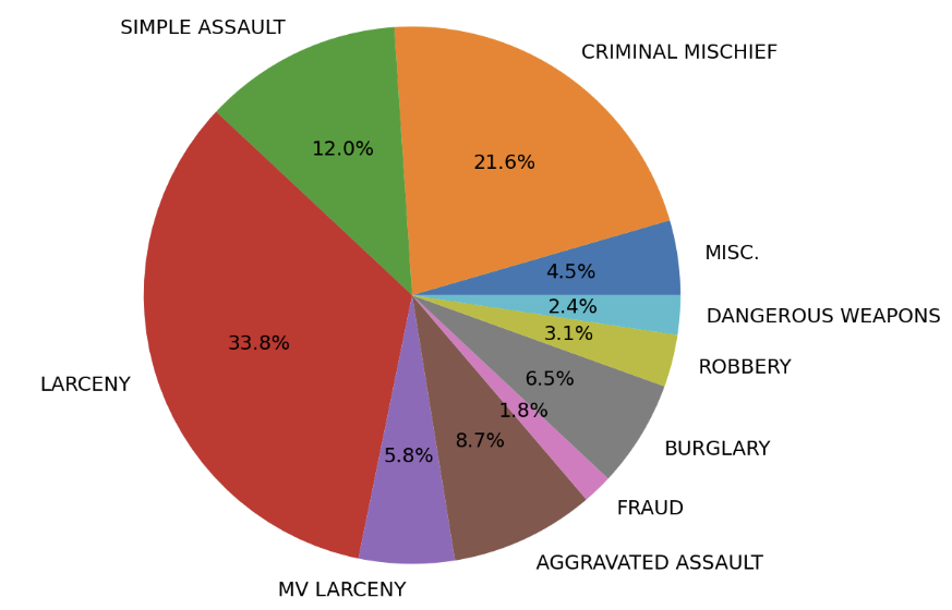
Figure 2, above, displays all UNIFORM CRIME REPORT between Jan. 1st, 2020, through Mar. 8th, 2025 after NO CRIME and ALL OTHER were removed. This data represents reported crimes. Percentages were renormalized, and the MISC. field contains the sum of all reports with less than 1%, i.e., MURDER.
The top 10 crimes and their counts are presented below in Table 2, with LARCENY (33.8%), CRIMINAL MISCHIEF (21.6%), and SIMPLE ASSAULT (12.0%) as the top 3 crimes.
| Number of Incidents (2020-2025) | Percentage of Total Incidents[%] | Uniform Crime Report |
|---|---|---|
| 12117 | 33.8 | LARCENY |
| 7742 | 21.6 | CRIMINAL MISCHIEF |
| 4298 | 12.0 | SIMPLE ASSAULT |
| 3122 | 8.7 | AGGRAVATED ASSAULT |
| 2316 | 6.5 | BURGLARY |
| 2070 | 5.8 | MV LARCENY |
| 1129 | 3.1 | ROBBERY |
| 849 | 2.4 | DANGEROUS WEAPONS |
| 642 | 1.8 | FRAUD |
| 356 | 1.0 | RAPE |
Crimes by Month - 2020-2025
The first crime trend we examined was the total number of monthly crimes. We wanted to examine whether the crime rate had increased, decreased, or remained constant since January 2020.
Each point represents the count of all crimes reported in a given month. Reports from March 2025 were excluded because our records ended on March 8th. We believe that the best way to visualize the overarching trend over 5 years of data is to use a linear regression trend line. The value of this trend line is that it is showing you the overall trend and will not show dramatic changes if there are sudden short drops or increases. Our trendline shows the changes in the data that are both significant and persistent over the 5-year time period we analyzed.
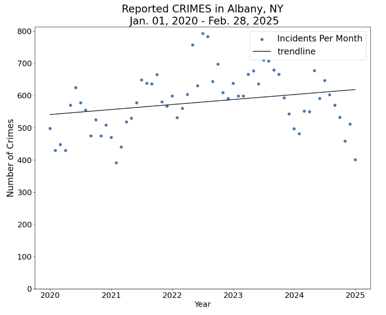
Figure 3 shows a general rise in the overall number of reported crimes, with the most reported crimes occurring in mid-2022. Despite this spike, 2022 and 2023 had approximately the same number of reported crimes. We provide the total number of crimes reported for each calendar year here, excluding 2025, along with the percent change below.
| Year | Reported Crimes | Year over Year Change [%] |
|---|---|---|
| 2020 | 6,118 | - |
| 2021 | 6,665 | 8.9% |
| 2022 | 7,803 | 17.2% |
| 2023 | 7,714 | -1.1% |
| 2024 | 6,674 | -13.5% |
Table 3 (above): Reported crimes by year and year-over-year change (%)
There was a significant drop in the number of reported crimes in 2024 relative to 2022 and 2023, which had approximately the same number of crimes. Our level of crime has returned to 2021 levels which, of course, was a COVID-19 pandemic year. There is not enough data or information to suggest whether this trend will continue through 2025. Furthermore, this drop may be attributed to certain types of crimes, which we revisit later.
The cyclical data presented in Figure 3 also inspired us to group the crimes by month. To normalize for the large year-to-year fluctuations, the yearly percentage of crimes occurring in any given month was calculated rather than the average number of crimes. This maintained the seasonality aspect we were interested in exploring. Several factors may contribute to this change, such as city schools and college students living in Albany, warmer weather, and longer daylight. Winter months in Albany are colder, and travel may be more difficult in winter months, especially after a snow or ice storm. All of these factors could impact the rate at which crimes occur at outside locations.
This led us to our first hypothesis: more crimes were occurring outside during warmer months. To test this assumption we grouped crime data based on LOCATION TYPE by splitting all crimes into a few broad groups: OUTSIDE (STREET, PARKING LOT, YARD, OTHER OUTSIDE LOCATION, GAS STATION, AUTO SALES LOT, FIELD WOODS, CONSTRUCTION SITE, PARK PLAYGROUND, LAKE WATERWAY, CEMETERY), INSIDE, and UNKNOWN; however, neither INSIDE or UNKNOWN were not analyzed as part of this article, but we may revisit that data in a future Albany Data Story.
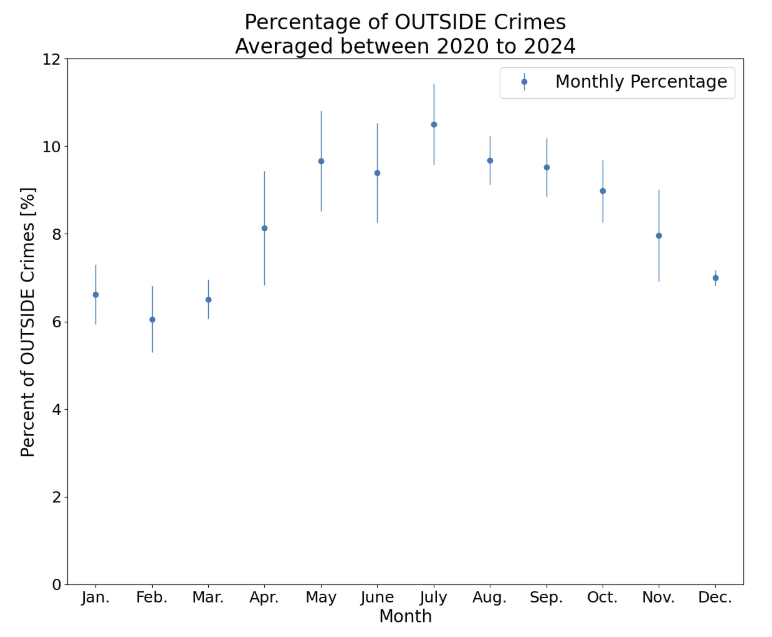
A total of 10,922 crimes were classified as OUTSIDE, and Figure 4 shows a more profound increase from May to August before trailing off for the remainder of the year. An average increase of approximately 25% was observed in May-August compared to December-March. This inspired us to further group the data using tags from the UNIFORM CRIME REPORT into three categories:
THEFT - LARCENY, MV LARCENY, STOLEN PROPERTY, BURGLARY, ROBBERY, EMBEZZLEMENT, FRAUD, FORGERY, UNAUTHORIZED USE, EXTORTION
VIOLENCE - SIMPLE ASSAULT, AGGRAVATED ASSAULT, MURDER, SEX OFFENSE, KIDNAPPING, RAPE, COERCION
OTHER - CRIMINAL MISCHIEF, ARSON, CONTROLLED SUBSTANCES, DANGEROUS WEAPONS, OFFENSES AGAINST FAMILY, DISORDERLY CONDUCT, OFFENSES AGAINST PUBLIC ORDER, GCO, DWI, GAMBLING, POSS OF BURGLARY TOOLS, PROSTITUTION.
The purpose of this division was to separate crimes into two broad groups that reflect a crime done to an individual (VIOLENCE) or their property (THEFT), and to see if either of these categories showed a similar increase from May to August. The remaining ambiguous tags were lumped together into OTHER. We feel strongly that an in-depth analysis could be made on any of these crime tags, especially those that fall under OTHER; however, at this time, the broad grouping into these categories better helps us examine trends and not draw conclusions based on small sample sizes.
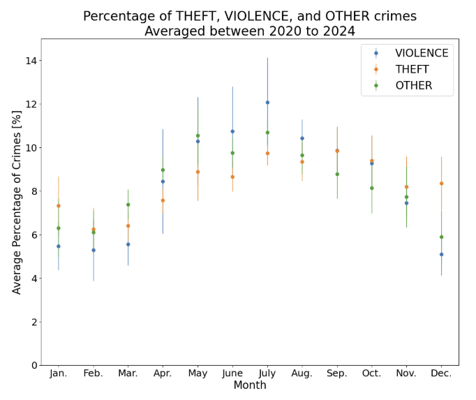
By separating crimes initially labeled as OUTSIDE into three categories, we can more easily observe a stark difference in crimes labeled as VIOLENCE from May to August (above 10%) relative to December to March (less than 6%). THEFT remains the most constant throughout the year, but is lower on average for the first three months. The frequency of crimes categorized as OTHER tends to fall between THEFT and VIOLENCE. In total, 5519 were classified under THEFT, 2188 were classified as VIOLENCE, and 3215 crimes were classified as OTHER. The breakdown by year is provided below. Increases year-over-year are highlighted in red, whereas decreases are highlighted in blue.
| Year | THEFT | Change [%] | VIOLENCE | Change [%] | OTHER | Change [%] |
|---|---|---|---|---|---|---|
| 2020 | 923 | - | 404 | - | 660 | - |
| 2021 | 916 | -0.8 | 422 | 4.5 | 596 | -9.7 |
| 2022 | 1369 | 49.5 | 396 | -6.2 | 651 | 9.2 |
| 2023 | 1183 | -13.6 | 447 | 12.9 | 683 | 4.9 |
| 2024 | 1027 | -13.2 | 468 | 4.7 | 547 | -19.9 |
Table 4 (above) - The number of OUTSIDE crimes categorized as THEFT, VIOLENCE and OTHER, by year, with year-over-year change (%).
We consider this to be one of the most interesting findings from our study. The peak number of THEFT crimes occurred in 2022, and has subsequently declined in both 2023 and 2024 by 13% each year, but is still higher than in 2020 and 2021. VIOLENCE crimes have generally risen each year since 2020, with 2022 being the one year showing decline.
Next - in part 2
In part 2 of our review of Albany crime data, we will examine where crime happens. This will include heatmaps and viewing crime data by neighborhood and demographics.
Have questions or comments on part 1 of our article? Email us at albanydatastories@gmail.com
Wonder what data stories we are working on next? See our current queue here! We are always looking for people to suggest additional stories and people who want to assist with any data analysis and authoring.
Data
This article uses a single source dataset obtained via FOIA from the Albany Police Department (APD) on March 16th, 2025, received in XLS format. The source dataset includes 78,094 records that describe Incidents between Jan 1, 2020 to February 28, 2025.
Fields in the source data include:
- INCIDENT - a unique ID for each incident, e.g. "20036353"
- REPORT DATE - the calendar date of an incident, e.g. "1/9/2023"
- REPORT DAY - the day of the week of an incident, e.g. "SAT", "MON"
- CRIME CLASSIFICATION - an internal classification scheme used to describe a portion of the incidents. Note that we did not use this field because of the incompleteness of the information
- LOCATION TYPE - the general location of an incident, e.g. "PROFESSIONAL OFFICE", RESIDENTIAL FACILITY", "SCHOOL"
- UNIFORM CRIME REPORT - a description of the incident using the FBI's Uniform Crime Report definitions
- HUNDRED BLOCK - this contains a semi-anonymized location (not a house number + street) such as "000 ACADEMY RD" and "WEISS CT & WHITEHALL RD"
Process
This section details various processes used during the analysis.
Geocoding - This file was geocode using two processes - 1) a process that used the street name and the midpoint house number for any given Hundred Block address and 2) a street intersection geocode (performed using MapInfo Professional and a 2024 TIGER/Line file containing street names). We successfully geocoded approximately 97% of the crime file.
Neighborhood tagging - Given the geocoding, we performed using an enhanced Zillow neighborhood file. The Zillow neighborhood file was incomplete for the surface of Albany so we digitized in an additional 10 neighborhoods, e.g. a boundary covering "Colleges, AMC and Lincoln"
Crime Categorization - As noted in the article, we categorized all incidents by THEFT, VIOLENCE, OTHER. In the Crime Part 2 article you will note that we slightly change the definitions.
Credits
This data story and its content is available under the Creative Commons Attribution license.
Persons or organizations that Share or Adapt this content should provide Attribution that provides appropriate credit, which includes:
- © Copyright 2025
- Tyche Insights, P.B.C.
- AdamTyche (Adam D)
- KarlTyche (Karl Urich)
- KeithTyche
For example, a data product or service that utilizes this article could include attribution such as:
"Portions derived from 'Albany NY Crime', © Copyright 2025 by Tyche Insights, P.B.C., AdamTyche, KarlTyche (Karl Urich), KeithTyche & licensed under the CC BY 4.0 license"